Innovative, practical and efficient specialist solutions to complex issues
PSM is a leading firm of consulting engineers, geologists, hydrogeologists, and hydrologists that has been delivering innovative and practical specialist solutions to complex issues for over 30 years. With a focus on providing specialist services such as engineering geology and forensic investigations, PSM has worked across multiple industries and scales, advising governments and businesses of all sizes. From geotechnical monitoring to DFN modelling, PSM's team of experts offers geotechnical specialist services that can help clients overcome a range of intricate challenges.
PSM's geotechnical consultants are renowned for their expertise in providing innovative and efficient solutions to complex issues. With offices across Australia and a global reach, we have a wealth of experience in tackling a range of geotechnical challenges, from site investigations to slope stability assessments. PSM's engineering geology consulting services are also highly sought after, as our experienced team have a deep understanding of geological processes and how they can impact engineering projects. With a focus on delivering practical solutions that are tailored to the specific needs of each client, PSM has a proven track record of success in delivering outstanding outcomes. Whether clients are looking for advice on a small-scale project or need support on a large-scale development, our team of experts can provide the specialist services needed to achieve outstanding outcomes.
Specialist Services Include:
- Engineering geology
- Forensic investigations
- Monitoring
- Photogrammetry
- Borehole imaging
- 3D modelling
- Discrete Fracture Network (DFN) Modelling.
Proven track record in temporary and permanent large underground rail, road and mining projects throughout Australia, Africa and Asia, including some of the largest-spanning tunnels in Australia.
CAPABILITIES
ENGINEERING GEOLOGY
FORENSIC INVESTIGATIONS
SEISMIC AND EARTHQUAKE ENGINEERING
MONITORING
Aerial Photogrammetry and Digital Mapping
BOREHOLE IMAGING
3D GEOLOGICAL MODELLING
DISCRETE FRACTURE NETWORK (DFN) MODELLING
ENGINEERING GEOLOGY
Our extensive knowledge and experience provides an invaluable resrouce in developing accurate and appropriate engineering geology investigations, models and design solutions.
Services include:
- Site investigation programs (design, supervision and completion)
- Engineering geology, geomorphological and structural mapping
- Geological and structural modelling
- Geological hazard assessment including landslide and earthquake hazard and related phenomena (i.e. liquefaction)
- Adverse ground conditions advice.
We use sophisticated tools and techniques, including:
- Remote sensing including the latest photogrammetry techniques and drones to inspect and photograph difficult access sites
- GIS applications for mapping, geohazard assessments, and modelling
- Televiewer and geophysical data interpretation
- 3D geological and structural models
- Discrete fracture network analysis (DFN)
- Drainage analysis to infer large scale structural and geological conditions
FORENSIC INVESTIGATIONS
Meticulous forensic investigation of geotechnical structural failures and catastrophic collapse.
Areas of forensic expertise include:
- Mine collapse
- Landslides
- Embankment collapse
- Damage to residential and commercial buildings from ground movement, foundation and retaining wall failures
- Damage caused by tunnelling, excavation, piling or other ground improvement works.
We also provide specialist advice in:
- Legal disputes
- Coronial inquests
- Remedial design and construction.
SEISMIC AND EARTHQUAKE ENGINEERING
A proven track record in seismic assessment and earthquake engineering in diverse geological and hazard environments in Australia, New Zealand, Papua New Guinea, Mozambique, Russia and South America.
Services include:
- Regional seismic hazard assessments
- Seismic monitoring
- Slope and foundations seismic analysis and stabilisation
- Detailed analysis for specific civil and mining projects.
MONITORING
Extensive expertise in the monitoring of geotechnical and civil structures from tunnels and open pit mine slopes to basement excavations and buildings.
Geotechnical structures monitoring, including:
- Ground strain and deformation
- Groundwater levels and pressures
- Negative pore pressures
- Soil pressure.
Manufactured structures monitoring, including:
- Deformation
- Strain
- Stresses and loads
- Tilts
- Water inflows.
Tailored monitoring ranges from simple prism-based to complex real-time systems. PSM innovations include:
- Robotic real-time monitoring (Hume Highway overpass at Glenfield)
- Development and construction of a large displacement inclinometer
- Digital crack pin monitoring
- Laser convergence logging systems
We use in-house software to interpret results, applying corrections where appropriate. We frequently use verification monitoring of designs undertaken during construction to optimise design, improve production rates and reduce costs.
Our easy to implement monitoring plans incorporate appropriate triggers and responses to effectively monitor risk of ground movement.
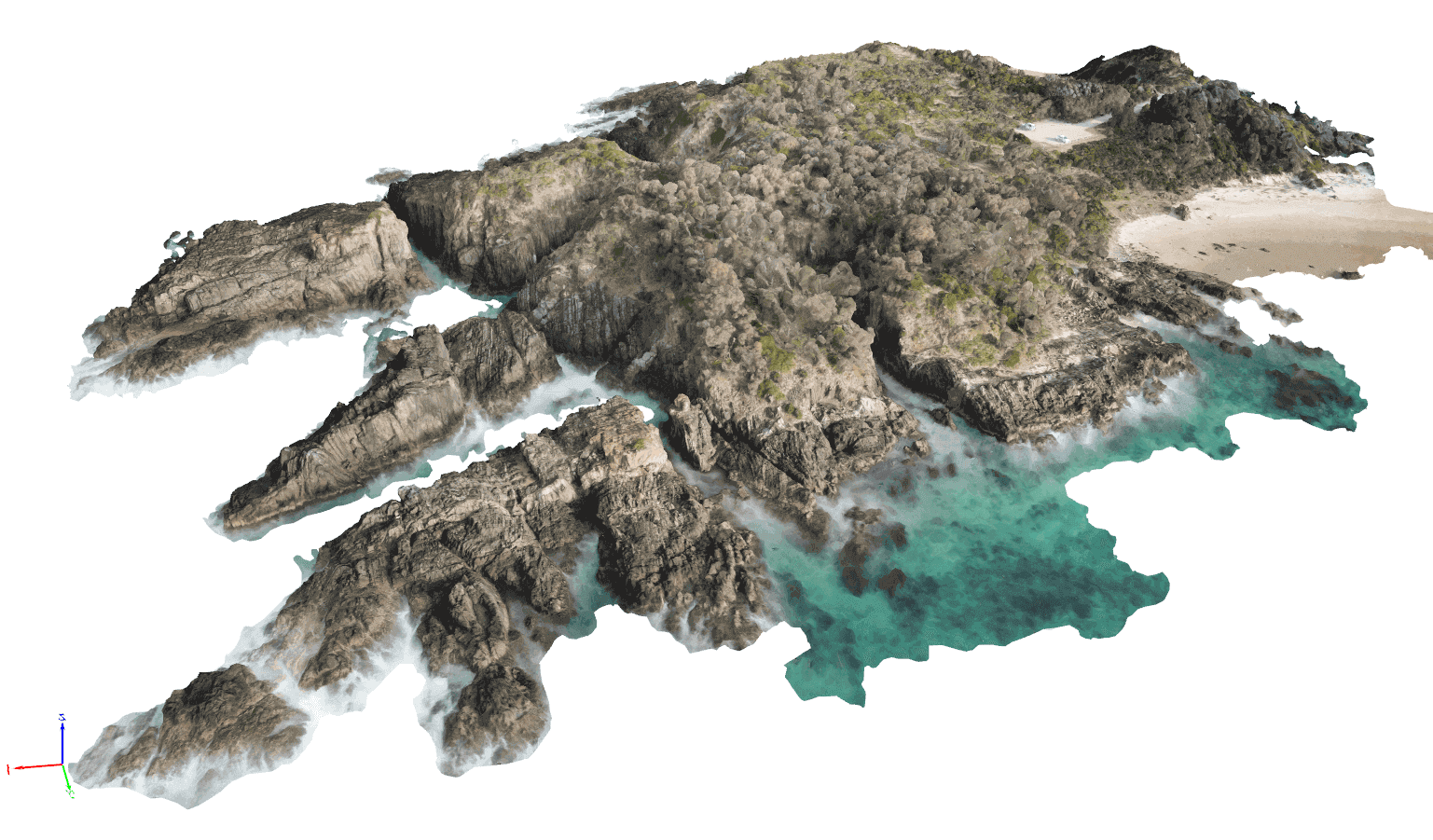
PHOTOGRAMMETRY
PSM have refined inhouse aerial mapping capabilities using remotely piloted aircraft which are routinely incorporated into our project delivery. We hold Civil Aviation Safety Authority (CASA) regulated remotely piloted aircraft operators’ certificate (ReOC) ensuring our pilots meet and exceed minimum safety standards while operating both on client controlled sites and in public spaces.
Aerial photogrammetry enables cost-effective, high-resolution datasets to be captured using Real Time Kinematic (RTK) equipped aircraft and aided with terrestrial ground control to ensure accurate georeferencing of the site.
PSM operate accurate and efficient three-dimensional mapping workflows allowing geotechnical assessments to be completed. This is particularly beneficial during site inspections, ground model development and geohazard assessments to solve complex geotechnical challenges.
Where required, PSM have established relationships with third party LiDAR and laser scanning providers to provide terrestrial, aerial and underground laser scanning solutions for our clients.
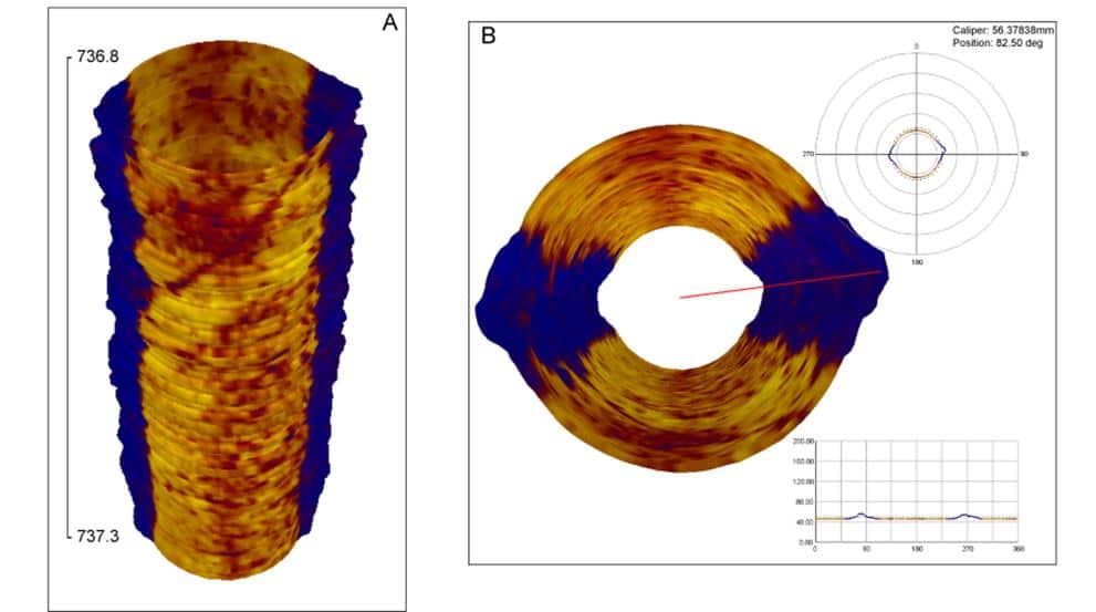
BOREHOLE IMAGING
In excavated slopes the orientation and characteristics of structures is crucial in slope stability.
PSM uses borehole imaging in core loss zones and poor rock massses to:
- Obtain reliable data
- Detect bedding orientation
- Prepare a break-out analysis
- Inspect casing
- Take high-resolution caliper measurements.
Borehole imaging produces a 360 degree oriented image of the borehole wall using an optical televiewer (OTV) and acoustic televiewer (ATV).
OTV is a direct image of the borehole wall using a ring of lights and a charged-coupled device (CCD) camera. OTV can only be collected in air or clear water intervals.
ATV is a pseudo image of the borehole wall derived from a high-density grid of ultrasonic acoustic measurements. The amplitude of the reflected acoustic signal is recorded as photographic-like images and the transit time used to calculate detailed caliper logs. ATV can only be collected in borehole intervals where there is gas-free fluid.
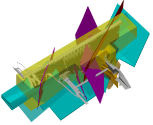
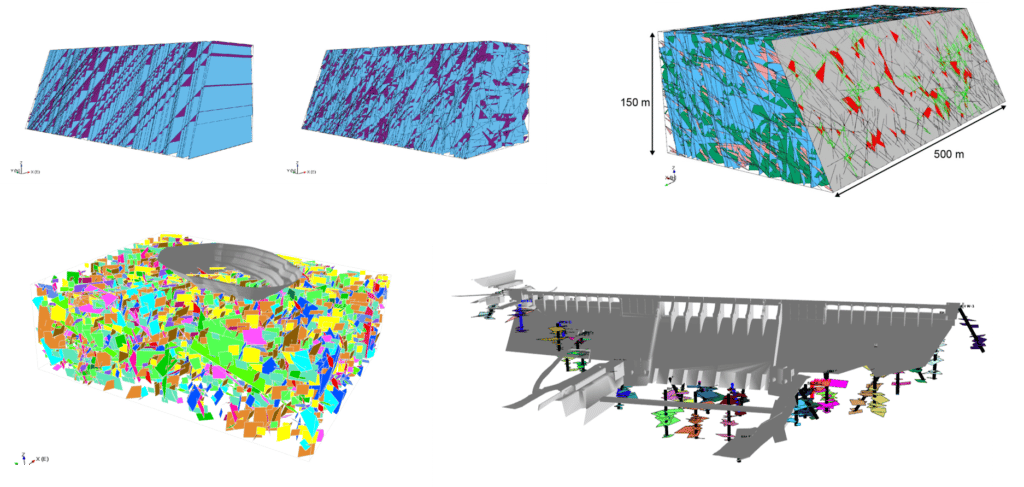
3D model showing extrapolated solids amid Andesite host block before truncation
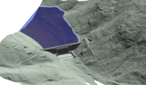
3D model showing triangulated surface profile of valley topography and lake bathymetry. Dam model and representative water level for scale and reference.
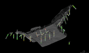
3D model showing boreholes displaying lithological units and downhole optical televiewer (OTV) structural halos.
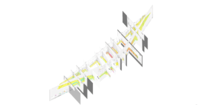
3D model showing imported sections and georeferenced in space using control grid
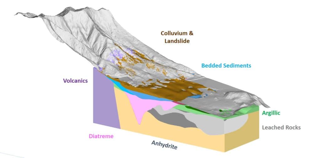
3D GEOLOGICAL MODELLING
PSM’s 3D modelling is a powerful geology visualisation tool which enables us to query data, rotate, hide and review geological conditions.
DISCRETE FRACTURE NETWORK (DFN) MODELLING
- A discrete fracture network (DFN) approach involves numerical modelling that explicitly represents how defects may be spatially distributed through a rock mass.
- The approach utilises structural data in stochastic analyses to give a range of possible models that provides a tool for visualisation of a rock mass and indicates the potential large-scale slope or tunnel performance and stability.
- PSM have over 10 years of experience in the application of DFN modelling for geomechanical purposes. Example applications include pit slope stability, civil and mining underground tunnels, shaft development and understanding rock bridges for dam foundations.
Work with geotechnical specialists who are committed to providing industry leading specialist consulting & solutions
PSM’s geotechnical specialists have worked across multiple industries and scales, on projects of all sizes for clients of all types. Our work is highly regarded and utilises cutting edge technology and methodology to get the most insightful and effective results. Although PSM was founded in Australia, our firm has a global reach and a wealth of experience in providing specialist expertise on nearly every continent. Whether our clients are looking for geotechnical investigation services, geological consulting, or other specialist services, PSM's team of experts is committed to delivering industry-leading consulting and solutions to meet their needs.
Contact
About our Specialist Services
With a range of specialist services on offer, including geotechnical forensic investigations, borehole imaging, 3D geological modelling, and photogrammetry, PSM can provide practical and innovative solutions to even the most complex issues. We understand that each client has unique needs, and we're committed to delivering tailored solutions that meet those needs. Whether you're a government agency or a private business, we have the expertise to help you achieve outstanding outcomes. Our team of geotechnical specialists use advanced technology and methodology to provide insightful and effective results.
If you're facing a complex issue or want to ensure that you're working with the best in the business, reach out to PSM today. We would be happy to discuss your needs and see how we can help. Contact us to learn more about our specialist services and how we can help you achieve your goals.

Hendrerit elementum dolor vitae quam sit blandit mauris, nunc. Ut convallis enim ac, et vestibulum risus bibendum interdum congue. Id posuere suspendisse dictum faucibus in nisi velit tellus. Posuere quis pretium imperdiet sed quis tincidunt lacus nullam.